Date: 21st February 2010
Time: 7 hours (including stops and backtracking to retrieve ice axe)
Munros: Sgairneach Mhor, Beinn Udlamain, Gael-Charn, A'Mharconaich
Distance: 14.77 miles
Ascent: 1,545m (5,068ft)
Route: View on OS Maps
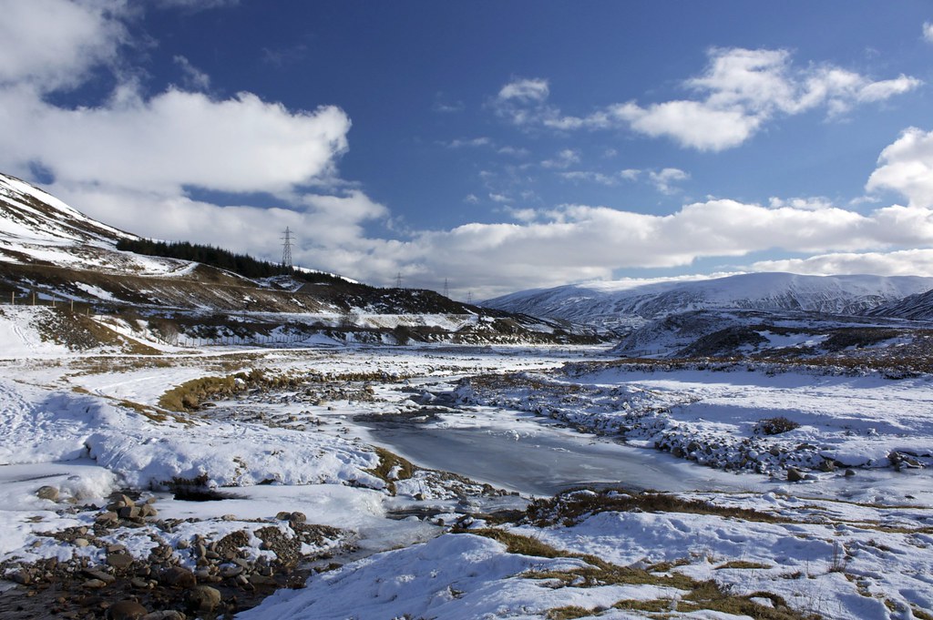
The car thermometer read -9oC as I cautiously left Aberdeen on the seemingly well gritted A90. My basic plan was to climb some mountains from a main road with the thought that at least getting there would be largely ice-free. Thankfully there is little moisture in Scotland at the moment and so all the roads were fine and I never had a traction problem. Even so I still took it steady and in the end it took around 2hrs 30 to get to the summit of the Pass of Drumochter on the A9. From joining the road at Dunkeld it had been a superb drive, crossing icy rivers with snow capped mountains lining the road.
I didn't fancy doing this round from Balsporran and ending with a depressing trudge back besides the road so chose Lay-by 79 as base camp for an assault on the Drumochter Four. Doing so would mean a little bit of back tracking from Gael-charn but would at least keep me away from the horrible traffic noise.

The sun was just starting to light the very tips of the mountains as I stood by the car, breathing in the frigid, stunningly still air. Booted up and on the track for 7:50 I was first in the lay-by and, once I'd gone under the railway line and left the road behind, had the hills to myself. Although it had been clear on the east coast there was low broken cloud over the A9 but this gave a beautiful dawn light over the icy Allt Coire Domhain.

The track was covered by a mix of footprints and ski trails leading into the still, dark depths of Coire Domhain. The climb at first is gentle and the views of my first Munro of the day, Sgairneach Mhor, were superb with the sunlight just catching the crags of its east facing cliffs. After passing the Sow of Atholl I headed down to the Allt and, accompanied by some creaking and groaning, skated across the ice covered waters. My left foot got slightly damp as the far bank was less stable but all in all it was a good crossing.


On the other side I climbed steeply out of the defile and aimed for the ridge-line to the right of the 758m minor top. Soon I picked up ski tracks and footprints that were headed in the same direction and followed these as they rapidly climbed the northern slopes. The views opened up all around me as I climbed. The hills were being bathed with beautiful sunshine as the early cloud cleared. Beyond the A9 I could see the other Drumochter hills and further north were the western reaches of the Cairngorms and hills around Aviemore. It was amazingly still and quiet and the crystalline carpet of powdery snow was a joy to climb through. I saw a couple of Mountain Hares away in the distance.


On the ridge the various tracks joined to make a beeline over multiple false summits to eventually reach the stump of a trig point marking the summit of Sgairneach Mhor. It was 9:30am and I was impressed with my rapid progress. I had been undecided about doing three or four of the Munros on this side of the pass but with good views and decent conditions underfoot decided that four would easily be achievable.


The view from the summit was quite something. Ben Alder directly ahead of me was burning off its cap of early cloud and far to the east I could see the hump backs of Beinn a' Ghlo. The Cairngorms looked majestic.


The descent to the head of Coire Domhain was a delight, though would have been even more fun with skis. Walking directly towards Ben Alder meant the views were astonishing and in no time I was at a line of fence posts and climbing up the broad southern flank of Beinn Udlamain.

The ice and snow had done wild things to the line of fence posts. I kept pausing to look at the developing views of Loch Ericht and the icing caked slopes of the hills around Coire Domhain.


The cairn at the top of Beinn Udlamain was reached with little effort at 10:20am. I dropped briefly down the western side to get a better view of the spectacular trench that contains Loch Ericht. After this I returned to the cairn and sheltered in its leeward side enjoying a brew and munching on a cereal bar. It was the first real stop of the day and immediately I felt the biting cold of the air. My hydration system was a waste of time having been frozen solid since before I reached the Allt crossing!


After restoring feeling to my fingers I headed off the northern side of Beinn Udlamain, heading towards the col between it and A'Mharconaich which was wreathed in a dramatic looking cloud. Away in the distance I could also see Gael-Charn and with the bright sunshine it was an easy decision to head that way. From the col I contoured around the north-western side of A'Mharconaich, climbing gently to avoid the steep-sided corrie which was evident from the contours on the map. I dropped down another ski run to the bealach at the head of Coire Fhar. Whilst negotiating the final slopes I came across a pair of Ptarmigan, almost hidden in their winter coats.


After seeing no-one for the entire morning I suddenly came across the tourist route with multiple parties heading between Gael-charn and A'Mharconaich. I got some strange looks as I started ascending Gael-charn, going against the flow of humanity.


Gael-charn is the best view point to appreciate the grandeur of the whole Ben Alder group, sitting above the narrow length of Loch Ericht. Away to the south other mountain groups were peaking out of a fluffy, white blanket of cloud. Gael-charn is a slightly narrower affair than the other Munros on this round but nothing extreme and the views all around were superb. I reached the summit at midday, just as a pair on skis arrived from the north. At the other cairn there were plenty of people stopped for lunch and taking photos. I exchanged pleasantries with the pair of skiers and then dropped off west again to find a spot for lunch with a perfect view of Ericht, Alder et al. The summits are broad enough here that you don't get to appreciate the full impact of such a view without dropping off slightly. It was wonderful and wasn't commanding the same sort of attention as the busy summit. I ate my lunch in solitude, marvelling at the view.


After lunch I retraced my steps to the summit, went over to the other cairn (just in case it was higher!) and then headed back down Gael-charn, following my upward route. I crossed over the head of the coire and then started up the steep slopes of A'Mharconaich. There had been multiple paths beaten through the snow but I chose to climb to the skyline which was retreating into a band of cloud that just clung to the summit. It was a bit of a slog but eventually I reached the ridge and followed it left through thick whiteness to the summit cairn, arriving at 1:30pm.


The cloud was beginning to shred as I considered my descent options. Earlier in the day I had seen a decent set of tracks coming off the side of the nose of A'Mharconaich but in zero visibility I wasn't confident of being able to find the start point for this steep and potentially dangerous route. I did investigate the area immediately south of the summit but some came to the lip of a small cornice so retreated and instead followed the footprints back along to the west until I hit the second top on the summit plateau where a line of fence posts bisects the ridge. Here I turned south, keeping the fence on my right and found much gentler slopes to descend. About 20m below the ridge I dropped out of the cloud and then had an ace time glissading down the snow until I reached the lumpier ground just above the coire track. I picked my way through to the track where I paused for a final snack.


It was lucky I did this as a quick check showed me I had lost an ice axe on the way down at some point. It had to have been during a glissade. Very annoyed (the Mountain Hare's had trouble covering their ears) I stowed my sack behind a set of concrete blocks and headed back up the mountain. I had to re-ascend around 250m until I got to the foot of one of my glissade runs. There was the axe lying on the snow. Relieved I glissaded back to the bag and headed out on the coire track.

The lighting conditions were markedly different now it was mid-afternoon and there was broken cloud hanging over the mountains giving spectacular views. It was also warming up with the sunlight and the snow and I shed a couple of layers before I arrived back at the car at 2:50pm. Discounting the 25 minutes I spent going up and down the slope to get my axe it had taken me 6hrs 30 to do four Munros in heavy snow. I think my hill fitness has been restored!

The late afternoon sunlight over the A9 was wonderful as I headed back and with the temperature now a balmy 5oC it took me only a little over 2 hours to get back around to Aberdeen. It had been quite the day, and now writing this I can feel the slight sting of sunburn. Oh, for every weekend to be like this past one!
