Distance: 15 miles
Time: 8 hours
Ascent: 5,600ft
Hills: Cnap Cruinn (Graham, 742m), Stob a' Choire Mheadhoin (Munro, 1106m), Stob Coire Easain (Munro, 1115m)
Weather: Hazy sunshine, clearer early afternoon, very strong Southerly wind
Route: View on OS Maps
With MWIS promising brighter skies by early afternoon following a damp start I decided to use this as an excuse to make the long journey across country to Glen Spean in Lochaber. At Spean Bridge I turned off the main Fort William road and drove up the narrow road to Corriechoille. Beyond the farm the road is rough but didn't pose any problems for my Fiesta. I went through the first gate and then parked at the area just in front of the second locked gate.
By 9:30am I was booted up and climbing the reasonably steep track up through the remains of a wood. It was sad to see that the majority of the trees have been felled in this area. Hopefully there will be some restoration work as it makes for a particularly soulless beginning and end to the day. As I climbed I thought I spotted someone watching me from up the slope. It was an uneasy feeling but as I got closer I discovered it was a wood carving…! After that encounter, and with heart now racing at maximum speed, I was up the hill in no time. The Corbett Cruach Innse came into view as I dropped down and crossed the river by way of a sturdy bridge.

At about 269771 I left the track and climbed up greasy slopes to the bealach below Cruach Innse. The views up onto the eastern end of the Grey Corries were marred only by the insistently grey skies.

The air was incredibly hazy so the views weren't anything special as I topped the bealach. I dropped down to the Allt Beinn Chlianaig which runs between the Innses and the long hill called Cnap Cruinn. Out of the shelter of Cruach Innse I was buffeted by a strong southerly wind which would be my nemesis for the first half of the day.

I crossed the stream at 284776, picking my way across the rocks, and then headed up heather-clad slopes to the northern top of Cnap Cruinn, marked Beinn Chlianaig on the map. This would have been a good vantage point east and west down Glen Spean and up towards Laggan but for the haze. I took a few moments sheltering from the wind to have a snack and then turned south, into the wind and heading for the Graham's southern, higher top.

The terrain was lumpy with several peat bogs to cross and no signs of footprints besides those of sheep. The Easains themselves were shrouded in cloud but I enjoyed the hazy views west to the Innses and beyond them to the Grey Corries, including the distinctive and solitary point of Stob Ban.

I took another break at the small cairn marking the summit of Cnap Cruinn before descending down gentle, grassy slopes into Coire Laire. The river was fairly high in places but I found a reasonable place to cross at 308756. Though I waded, the water didn't come over my winter boots so I stayed dry.

From here it was a brutal slog up the very steep northern slopes of Stob a' Choire Mheadhoin. The river in Coire Laire was at 1,200ft whilst above me, the summit of the Munro was at over 3,600ft! I roughly followed the line of the Allt na Craige Tarsuinn which tumbles down a series of falls lower down whilst still being choked with snow higher up. I paused often and noted that the haze was lessening with views now more distinct over the Corbetts behind me and Creag Meagaidh to the north-east.


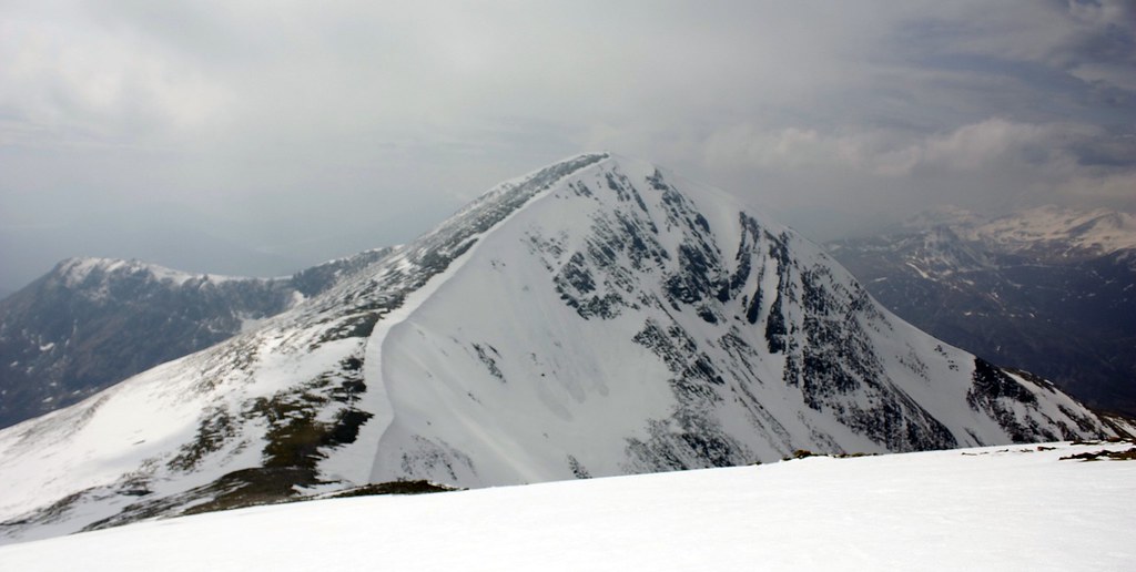
The upper reaches looked craggy but it was fairly straightforward to pick my way through them and finally I emerged on the shoulder of Stob a' Choire Mheadhoin. This was rocky and still largely snow covered but I found a way easily across the shallow slopes to finally join the standard bagging route from Fersit at 318738. I had seen a couple of walkers in the distance but when I finally crested the rise to the summit it was deserted and misty. The top of Mheadhoin is fairly featureless and the main attraction is the view ahead to Stob Coire Easain which has a fantastic north-east face.

I dropped down to the bealach between the two, wading through delightfully powdery snow and then started to climb the track on the far side.

Just as I started a group of walkers passed me heading back for Mheadhoin. The two walkers who I had seen on the previous hill were now just ahead of me. I spent some time admiring the eastern corrie and the cornices before climbing up to the large cairn and the magnificent summit of Stob Coire Easain.


The views from here were quite stunning even without pristine air quality. I sat down just besides the summit and drank in the views. The two chaps also paused up here taking on board food and drink and discussing the day.


After this enjoyable rest, basking in the hazy sunshine, I dropped north of the summit and soon picked up a track running down the north ridge. This proved very, very steep and snow covered for much of the descent and there was a constant tumble of stones and rocks as I made my way down. The track runs very close to the edge of the ridge with the cornice just a short distance away. I was very glad to make it down to gentler ground where, after descending through two lines of crags I hit more level terrain.


I admired the views down into Coire Laire and then picked my way on a distinct track down towards the Lairig. Now I had views onto the intimidating southern face of Sgurr Innse. My original plan had been to climb this and then go over Cruach Innse to rejoin my outward track. However, by this point I was becoming tired and as I sat down finishing off some chocolate and trying to figure out a way up through the crags I decided to abort this plan and return by the Lairig road.

It wasn't an easy decision as the mountain looks a lot of fun, but feeling tired and still with some way to go, I didn't feel that I could trust my decision making if I got into trouble high up on an exposed crag. The mountains will still be here when I return. So it was that with some reluctance I dropped down from the peaty bealach to where the Lairig Leacach track fords the stream at 283738. Up the other side I joined the road just north of the Bothy which sits in an impressive location below Stob Ban.

From here it was a simple case of walking the 5km out back along the road, getting excellent views up onto the Innses, waking a few sheep from their afternoon naps, and eventually arriving back at the car just on 5:30pm, 8 hours after setting off.

Fish and chips at Aberlour broke up a return journey which got me back to Aberdeen for 9:30pm.