 Joe Dorward is passionate about that corner of the Cairngorm Mountains, largely west and north of the village of Braemar in Aberdeenshire, which is known as the upland of Mar. Beginning with camping holidays to the area as a young boy, he has spent many enjoyable days exploring the rivers and glens of this rambling area of rough moorland and heathery hills, and is gradually constructing his guide to them, a fabulous website called the the upland of Mar.
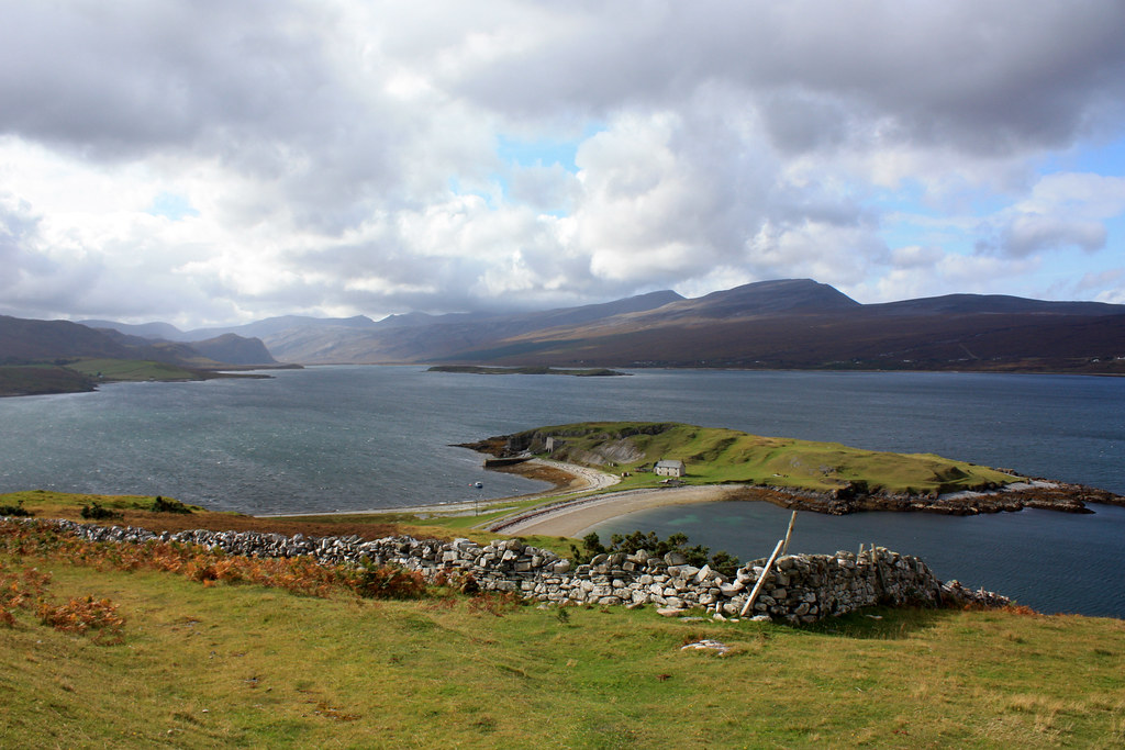
Crathie to Ballater (via some hills)
Date: 7th January 2012
Distance: 19.43km
Ascent: 562m
Time: 5hrs 57mins
Hills: Sgor an h-Iolaire, Creag nam Ban, Creag Ghiubhais
Weather: Overcast and light rain showers. Some sunshine. Very strong winds on the tops.
Route: View on OS Maps
With the weather continuing to threaten high winds and unpleasant conditions on the tops, Dave and I decided to try a low level walk making use of the service bus going out from Aberdeen to Braemar. The basic plan was to jump off at Crathie and then make our way back east along the river to Ballater, going over a number of small sub-600m bumps that lie along the south bank of the River Dhé. These hills don’t really feature on any lists (though I’m told one is a Marilyn) so we were assured a quiet day with plenty of pathless wandering.
Snow Showers and Icicles - A Meander Around Glen Tanar
Date: 2nd January 2012
Distance: 30.00km
Ascent: 920m
Time: 6hrs 8mins
Hills: Mount Keen (Munro, 939m), Gathering Cairn (790m)
Weather: Cold, bright sunshine in the glen during the morning. Later high winds and snow showers.
Route: View on OS Maps
With my car on the fritz and an uncertain weather forecast I decided to do a local walk to kick-start 2012. Mount Keen is the most easterly Munro and can either be accessed from the south via Glen Mark (the more popular route) or from the north via Glen Tanar (as well as more adventurous and less trodden routes coming in from either the east or west if you prefer). I’ve done both the northern and southern approaches in the past but must say that I prefer the delights of the Glen Tanar approach which also has the benefit of being slightly closer to Aberdeen and on better roads. In his Christmas special Coast to Coast from Aberdeen to Knoydart, Cameron McNeish came by way of Glen Tanar to Mount Keen and the time he spent there demonstrated the attractions of this particular glen. The estate are working to regenerate the Caledonian Forest and they maintain good tracks through the woods and upper, wilder parts of the estate as well as providing a walkers car park at the entrance.
2011 in the Scottish Hills
As 2011 draws to a close and the weather is wild and windy outside, I thought it a good opportunity to browse back through the reports and photos from my trips out in the Scottish hills over the past twelve months and put together a quick summary. A mild and wet December is now fizzling out and looking back it is hard to believe how warm and sunny the early spring was.
Down and out on Gael Charn
Date: 13th November 2011
Distance: 20.74km
Ascent: 628m
Time: 6hrs 24mins
Hills: Gael Charn (Corbett, 821m)
Weather: Mild with light winds, later sunshine after cloudy start
Route: View on OS Maps
Outside it was dark and drizzly, Aberdeen shrouded in a clinging fog. The pavements were slick with rain and the traffic lights danced eagerly through their cycle despite the lack of an audience. The coach was thankfully warm and I got the back seat where with my iPod on I could catch up on some much needed sleep on the long crossing to Tomintoul. When I woke some time later it was light outside and the skies were looking much better. We had left the Aberdeen mist behind and bands of blue sky appeared as we rolled through the foothills of the Cairngorms, turning off the Nethy Bridge road and pulling up at the turning area near Dorback Lodge.
Ben Lawers or The Clouds Lie Below Coire nan Cat
But every silver linin' // Always seems to have a cloud // That comes my way
Date: 6th November 2011
Distance: 17.02km
Ascent: 1522m
Time: 6hrs 16mins
Hills: Beinn Ghlas (Munro, 1,103m), Ben Lawers (Munro, 1,214m), An Stuc (Munro, 1,118m)
Weather: Cloud inversion, cold, sunny, clear skies, very light wind
Route: View on OS Maps
The east coast sparkled with a heavy frost as I drove down the A90 early on Sunday morning. A thin mist filled the hollows and the sun, rising through a bank of sea fog, cast an ethereal light across the landscape. The colours were crisper and more vivid than anything you could hope to commit to film or chip. After seemingly weeks of wind and rain the utter stillness was quite breathtaking, even when travelling at 70mph.
Welcoming back Greenwich Mean Time on Scolty Hill
Drive. The city recedes in my mirrors. Head west into the low afternoon sun. Negotiate the muddy and pot-holed road and park. Laces tied, sack on, straight off into the forest. Mulchy, muddy ground under foot, blue skies above broken by white clouds racing through on a strong breeze. The …
Somewhere East Of Glenshee
Somewhere out in the mist a lonely stag roared. Besides the faint trickling of a nearby stream it was the only sound that could be heard through the muffling effects of the thick cloud. We were somewhere east of Glenshee and despite the lack of views all was good.
Date: 15th October 2011
Distance: 14.77
Ascent: 875m
Time: 5hrs 35mins
Hills: Carn an Tuirc (Munro, 1,018m), Cairn of Claise (Munro, 1,064m), Glas Maol (Munro, 1,068m)
Weather: Low cloud, strong winds on the plateau, mild.
Route: View on OS Maps
Sixteen Stockets bravely set out from the car park at the start of the path which eventually crosses to Glen Isla by way of the Monega Pass. Though there was rain in the air, it wasn't particularly heavy, and the real problem was the ground underfoot which was merely muddy in places, but a true quagmire in others. A short distance down the path we turned left to climb gently up besides the north bank of the Allt a' Gharbh-choire. The path here was a little better, with some solid gravel underfoot, and so we made swift progress up besides a couple of impressive waterfalls and so further up into the mist. The line of the road faded into nothingness as our world was reduced to the few meters around us; people just a few paces behind were fuzzy shadows.
Glen Einich and Braeriach Wild Camp
Date: 1st - 2nd October 2011
Distance: 32.77km (Day 1: 10.86km; Day 2: 21.91km)
Ascent: 1,384m (Day 1: 238m; Day 2: 1,144m)
Time: 22hrs 29mins (Day 1: 2hrs 2mins; Day 2: 4hrs 25mins)
Hills: Stob Coire an Lochain (Munro Top, 1,239m), Braeriach (Munro, 1,296m)
Weather: Rain on and off for the duration. Low cloud, mist, mild temperatures and no wind.
Route: View on OS Maps
I backed the car into the almost empty parking area at Whitewell and turned the engine off. Steam rose gently from the grill, a sign that the last puddle I’d driven through had been a little deeper than expected. The rain, which had been steady but mainly drizzly on the drive over from Aberdeen, now increased in intensity significantly. Without the windscreen wipers on my windscreen quickly turned into a waterfall, obscuring my view of the world outside. I wasn’t quite prepared for that sort of drenching so it was Jaffa Cakes and a few chapters of The Clash of Kings with the hope that the rain would at the very least ease off slightly.
North East Mountain Trust Winter Talk on Alexander Kellas
Last night at the North East Mountain Trust's first winter talk of the season, Ian R. Mitchell gave an interesting and entertaining talk on the “forgotten” Scottish Himalayan mountaineer Alexander Mitchell Kellas. Kellas made several notable first ascents in the Himalaya, including being one of the first Europeans to climb above 20,000 feet, but sadly died in Tibet in 1921 on the way to Mount Everest. As a member of the 1921 British Reconnaissance Expedition he met George Mallory who would famously disappear on Everest just three years later.